
Sometimes a great deal of insight about how landscapes change over time can be gained through relatively low-tech approaches.
A “repeat photography” project on Wyoming’s Bridger-Teton National Forest offers a case in point.
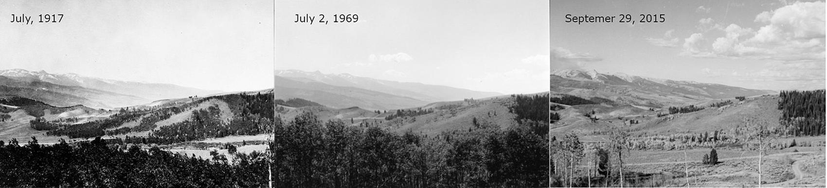
Three photos taken from the same location near Jackson Hole, Wyoming. Bridger-Teton National Forest photos.
Half a century ago, George Gruell, a wildlife biologist for the national forest, found a trove of landscape shots that were taken near the dawn of the 20thcentury. Intrigued, Gruell tracked down the precise locations where each photo was taken and snapped an image from the same vantage point.
Now, Bridger-Teton officials are revisiting those sites and capturing images of those scenes a third time.
The process is more difficult than you may think. Mike Merigliano, an ecologist who has been hired by the Forest Service to retake the photos, methodically tracks down the precise location where each photo was taken. He is careful to frame the images to match the previous photos, and considers other factors such as the season in which the older photos were taken.
The photos document the impact of natural processes such as wildfire and the worrisome advance of invasive species such as cheatgrass, as well as the consequences of a century of fire suppression.
Side-by-side photos can be viewed here. Bridger-Teton officials say they will use the images to inform land management decisions.
“The science and practice of land management is rooted in our understanding of natural processes,” the agency’s website says. “If nature cannot do it, we usually cannot either.”